FARO® Focus

Baru

FARO® Focus Laser Scanning Solution

A comprehensive solution designed for capturing precise 3D digital models, faster data sharing, and on-site efficiency.
sold

Produk ini telah habis stok

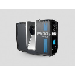
The FARO® Focus boasts the fastest time to better data through the unique power of Hybrid Reality Capture, powered by Flash Technology*. But great data capture doesn’t always mean a complete solution. While in the field, the Focus offers highly accurate 3D representations of any environment or object — even in extreme conditions — with real-time, pre-registered feedback through the included FARO Stream App. Transfer point cloud data to the FARO Sphere® XG Digital Reality Platform via Stream for faster decision-making and seamless transition to third-party software and to provide broader accessibility for key stakeholders.

The FARO Focus is a complete, easy-to-use solution for reality capture professionals, with intuitive hardware and versatile software offerings.

* Panocam is required to operate FARO Flash
Schedule a Live Demo

Business Value of the FARO Focus

Increase Productivity

Scan range options of 100m, 200m, and 400m and real-time feedback of pre-registered data through the FARO Stream App lead to faster and more comprehensive data capture.

Reduce the need for multiple setups, minimize errors or missed data, and enable faster on-site decision-making for increased productivity. The extended range of the Focus Premium Max is ideal for geospatial applications such as topographical surveys, boundary surveys, and large infrastructure projects.

Reduce Rework and Material Waste

Available in all Focus variations, Flash Technology increases data capture by over 50%, allowing for frequent on-site updates and ensuring projects are on track with original plans.

Greater visibility leads to earlier error identification and reduced rework and material waste.

From Small to Large-Scale Projects

The FARO Focus is an excellent surveying solution for capturing various areas, including large outdoor projects with its extended range and smaller areas with its speed of capture.

It is ideal for large construction sites, smaller public safety incidents, and everything in between.

Share Data Faster with Sphere XG

Upgrade to the Sphere XG Digital Reality Platform for seamless data sharing and collaboration. Effortlessly upload data from the FARO Stream App to Sphere XG, ensuring that all essential parties stay informed, regardless of location. This facilitates faster decision-making and enhances project visibility.

Versatile Data Processing

In addition to online data sharing via the cloud, FARO offers offline data processing in FARO SCENE.

For added peace of mind, the onboard SSD disk drive in the Focus scanners has 512GB of memory, which stores scans on the device and adds an extra layer of security around the data.

Interactive Registration for Large Complicated Projects

Efficiently process over 1000 scans and mix different registration types through the interactive registration tool in FARO SCENE.

This registration tool is ideal for larger, complicated projects and is designed to offer greater flexibility, speed, and easy georeferencing without expert information required.

FARO Focus Performance

Hybrid Reality Capture

FARO continues to bridge the gap between speed and accuracy with Hybrid Reality Capture, powered by Flash Technology*.

Flash Technology improves on-site productivity and ensures predictable accuracy on every project or forensic investigation.

Multiple Point Clouds, Multiple Devices

Sphere XG is designed as an easy-to-use data ecosystem containing data from various FARO hardware products. It allows users to bring in multiple point clouds from different sources to improve the visibility of a scanned area. This can facilitate better decision-making, project management, and collaboration with clients and stakeholders. Users can also review and compare multiple point clouds of the same location over time to understand changes in the data, track progress, and identify serious issues.

Software Compatibility

FARO offers a variety of export options for point cloud data to make importing into familiar third-party software, like Autodesk® ReCap, a smoother process.

Super-High Color Resolution

The latest color technology enables the Focus to capture scans with up to 266-megapixel color information for clearer point cloud data.*

*Panocam is required to operate Flash

FARO Focus Features

Halve the time spent scanning using Hybrid Reality Capture , powered by Flash Technology – Over 50% faster than traditional methods.
Improved scanning range—up to 400 meters—leads to superior area coverage per scan position. It is ideal for geospatial applications like topographical surveying, boundary surveying, or infrastructure projects.
No more "scanning blind".

Pre-registered data and greater visualization through the FARO Stream App help to identify gaps in the data or scan errors on-site in real time.
Upload data to Sphere XG and share it with key stakeholders for quicker decision-making or process data offline directly in FARO SCENE Software.
Control the scanner through the Stream App or directly on the screen through the intuitive interface.
Create projects, change scanner settings, manage image resolution, opt for color or black-and-white scans, group scans through clustering, and add annotations.
The rugged design, housing, and IP 54 rating help withstand the harshest environments daily.
Integrated high-speed SSD data storage of 512GB for maximum scan capacity and significantly faster processing.

Architecture, Engineering, Construction, and Operations

(AECO) Applications

Fast, Accurate Data Capture for Planning

Capture scan data to create accurate, complete datasets for various applications such as as-built documentation, Building Information Modeling (BIM), industrial facility management and infrastructure projects. These datasets form a strong foundation for conversions, extensions, space optimization, structural analysis, and maintenance.

Improved Construction Quality Control

Consistent and regular laser scanning during the construction process ensures that the final structure aligns with the design intent, reducing the risk of distortions and other issues. Calculating large volumes and inspecting free-form shape elements and facade components is also straightforward. Scan data is extremely valuable for project supervision and collaboration across different trades.

Scanner Versions

FARO Focus Premium Max

The FARO Focus Premium Max has a range of 400 meters with a 3D accuracy of up to 2mm. It is designed for geospatial applications and includes a perpetual license to FARO Stream and FARO Flash, a PanoCam Mount, and a manufacturer warranty of 2 years.

FARO Focus Premium

The mid-range FARO Focus Premium is suitable for architecture, engineering, and construction purposes, offering a scanning range of 200 meters and a 3D accuracy of up to 2mm. The scanner comes with a 1-year optional subscription to FLASH and a perpetual license to FARO Stream. Additionally, it includes a standard 2-year manufacturer's warranty.

FARO Focus Core

The FARO Focus Core is designed to suit various operations and public safety analytic workflows, offering a 100-meter range and up to 2mm accuracy. The scanner is available with an optional 1-year license to FARO Flash and a perpetual license to FARO Stream. Additionally, it comes with a standard 2-year manufacturer's warranty.

No customer comments for the moment.

Tulis komentar Anda

FARO® Focus

FARO® Focus

FARO® Focus Laser Scanning Solution

A comprehensive solution designed for capturing precise 3D digital models, faster data sharing, and on-site efficiency.

Tulis komentar Anda

Produk Sejenis