Tidak ada produk
Belum Termasuk! Pengiriman
Rp 0 Jumlah
Produk berhasil ditambahkan di keranjang belanja
Jumlah beli
Ada 0 produk di keranjang belanja Ada 1 produk di keranjang belanja
Total produk
Total ongkir Belum Termasuk!
Jumlah
Baru 


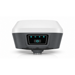
captuRTK™ TS30 Laser & Vision GNSS Receiver

Capturing and Reconstructing the Site
With captuRTK™ TS30, simply walk through the site and record a video. The system automatically reconstructs high-density point clouds with accurate spatial positioning. Next, users can directly obtain coordinates, distances, angles, topographic maps, and generate DLG, DTM, DEM products.
Hardware
Dimension : Ø134 × 90 mm
Weight : approx. 1050 g
Battery : 10000 mAh built-in battery
Smart battery power display : Supported
Laser & Visual
Laser range : 0.05–50 m
Laser safety : Class 3R
Distance accuracy : 8 mm
Laser measurement accuracy : 3 cm within 10 m
Point cloud visual positioning : Supported
TwinCam™ AR stakeout : Supported
Connectivity
Built-in 1W transceiver UHF : Supported
Built-in global 4G modul : Supported
Data output : Wired / wireless
Correction service : TAP Service and TAP Fill
Core software : Nuwa App and Tersus Geo Office 2
Data formats : JobXML / FXL / WMS / vector map formats
Compatible workflows : FieldGenius / TcpGPS / Makin3D / ProStar / easyGIS / Esri Field Maps / Pix4Dcatch
No customer comments for the moment.


